
CostQuest’s Broadband Fabric Data Suites are broadband-specific GIS and point-of-interest (POI) datasets built from our industry-standard Broadband Serviceable Location Fabric data. These datasets deliver precise, coordinate, and address-level location intelligence on market demand, broadband service availability, provider competition, funding status, cost to serve, net present value (NPV), demographics, and more for each location.
Used in federal initiatives like the FCC’s Broadband Data Collection (BDC) and the NTIA’s Broadband, Equity, Access, and Deployment (BEAD) program, these datasets help guide the effective distribution of federal funding for broadband infrastructure nationwide.
Designed for service providers, engineers, consultants, and government teams, the Broadband Fabric Data equips users with the trusted, granular data needed to drive broadband planning, deployment, operations, policy, and compliance—all in one dataset.
Plan to the point. Plan with confidence.
With 20+ years of experience in broadband planning and economic cost modeling, we designed these datasets to solve a common industry challenge: accessing accurate, granular, and comprehensive data to reliably inform broadband decisions.
Challenge & Solution
The cost of inaccurate data is measured in deployment errors & missed opportunities. Most broadband strategies fall short because they’re built on incomplete or imprecise data. Decisions that rely on census blocks or outdated maps can misidentify unserved areas, fail funding audits, or derail infrastructure deployments.
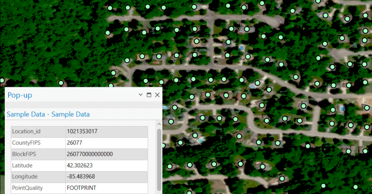
The Broadband Fabric Data Suites eliminate uncertainty. With over 115 million verified Broadband Serviceable Locations (BSLs), location-level service coverage, and full cost-to-serve modeling, CostQuest delivers data that’s defensible, geospatially precise, and ready for deployment planning, policy design, and investment and funding strategies.
Why decision-makers choose Broadband Fabric Data
Precision, reliability, and results—built into every dataset.

Verified Location Accuracy
Eliminate uncertainty with precise, validated data—no high-level, hex, or census block-level assumptions. Complete with coordinates, addresses, land use, unit count, and FIPS codes.

Built to align with Federal Programs
The universal and CostQuest unique Location IDs align with the FCC’s Broadband Serviceable Location Fabric, which underpins the FCC’s Broadband Data Collection, National Broadband Maps, NTIA’s BEAD, and other federal broadband grant programs.

GIS & SQL Ready
Delivered via CSV or GeoPackage, ready for GIS, SQL, and other analytical and data visualization tools. Easily analyze the data geospatially, or via the method of your choice.
Three Broadband Fabric Data Suites. One trusted source.
Verified location, broadband service, and infrastructure cost and economics datasets. Data is available for every U.S. state, territory, and county.
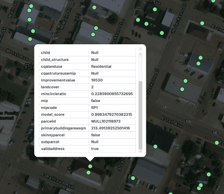
Location Data
Verified Location Intelligence
ServiceLandscape Data
Coverage, Providers, and Funding Insights
NetworkPlan Data
Network Cost Models, Financial ROI, and Deployment Risk
The truth is in the data
Explore the exact data categories included in each Broadband Fabric Data Suite.
Download the data instantly on TrueVerra – Our Data Marketplace.


Custom data you can add on
A data methodology that delivers
Millions of data points, proprietary models, field-tested intelligence, and visually verified.

Precision at the Core
Each Fabric dataset is developed using hundreds of data sources, proprietary algorithms, verified real-world inputs, to pinpoint every Broadband Serviceable Location down to the coordinate-level.
Built for Integration
All Broadband Fabric Data Suites are optimized for ingestion into GIS, SQL, or your preferred broadband mapping, planning, or data visualization system.
Designed for Action
From planning to implementation, the Broadband Fabric data is designed with the data insights you need to push your projects faster—with confidence in every number.
Explore Data Resources
Video Tutorials

Overview of Broadband Serviceable Location Fabric Data Suite Fields
Video Tutorials
How to Visualize Broadband Serviceable Location Fabric Data in QGIS
Video Tutorials
How to Analyze Broadband Serviceable Location Fabric Data in SQLite
From discovery to deployment in 4 simple steps
Step 1
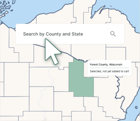
Select your geography(s) of interest on TrueVerra or Via Sales
Search by county to select the geography you need for your strategic planning and operational needs via TrueVerra Data Selection Map: https://trueverra.io/data-selection-map. Or contact our sales team for bulk geography or nationwide orders.
Step 2
Select a Data Suite
Choose from Location, ServiceLandscape, and NetworkPlan—all the data you need is right within your orbit.

Step 3
Download and Integrate
Datasets are delivered in CSV or GeoPackage (.gpkg) formats, ready to plug into your GIS platforms, SQL, broadband models, or internal systems. If you purchase the data through our TrueVerra platform, the data is delivered instantly upon purchase. If the data is purchased through our sales team, your data will be delivered to you through them.

Step 4
Analyze. Plan. Deploy
Upon downloading the data, you can now uncover location-level insights for your areas of interest to support strategic broadband planning, financial modeling, network design, internal data processing, compliance tracking, and beyond.
Proven in the Field
Real outcomes from real organizations.
Trusted by Federal Agencies, relied on by industry