State Broadband Expansion Center
Resources for developing a State Broadband Program
Broadband mapping in your state
No matter how large or small the organization is, or if they are an ISP, Engineer, government entity, consultant, etc., all who are working on expanding broadband access will need an accurate (state or regional) broadband map identifying the exact geographic placement of locations where broadband is, is not available, or not at a sufficient speed threshold (under 100 Mbps download/20 Mbps upload speeds and sufficient latency). Mapping broadband availability is all about identifying where internet connections are needed, but organizations must know exactly where a structure is and have an accurate representation of broadband service availability, in order to provide the correct link.
Mapping broadband availability across your region or state is the first major effort where you’ll need to determine, per the broadband definition (outlined in various broadband deployment funding programs), which areas are considered served, underserved, and unserved with broadband service. Building a granular view of this (ideally at the location level) into your map is a critical step in establishing a baseline in your map to work from. This begins the process of narrowing down which areas of the state should be eligible for funding.
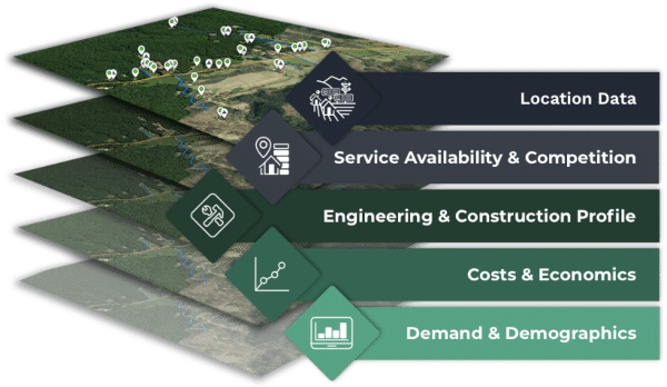
Take your time with this step, the more accurate and comprehensive the data is in your broadband map, the more effective your decision-making from your map will be. Be sure to feed your broadband map with geographically accurate and insightful data that gives you a clear picture of the broadband needs across your region or state. In terms of broadband service availability and adoption barriers, such as low-income, high service prices, etc. The data you acquire will then guide the subsequent analysis and decisions made from your map. Click here to dive deeper into what data is helpful to embed in a broadband map for effective broadband decision-making.
A common question(s) at this stage: How accurate is our foundational data (of Broadband Serviceable Locations)? Which areas are eligible under BEAD that we want to bid on? Do we want to remove areas funded by RDOF, CAF, or another program? What datasets are we missing? Who will build/maintain our map?
Precise broadband mapping comes in handy when targeting billions in broadband funding
Developing a broadband map that precisely locates virtually every structure where a broadband connection can be installed in your area, has been found as the most accurate and extensive method to ensure expanding broadband access is done effectively and efficiently.
Again, expanding broadband access is about connecting the areas in most need of service, but providers must know precisely where those structures are in order to provide a broadband connection.
This is why it’s important for you to develop geospatial maps at the location level or also called, the structure level or rooftop level, or address level, to ensure critical decisions are derived from a truly representative foundation of locations you can overlay broadband service availability and other critical information upon. For example, with an accurate base of reliable location information, you can add more precision to:
- Service availability reports
- Funding assessments and determination amounts
- Network plans and designs
- Cost/Financial models – account for how much labor, material, maintenance
- Report broadband availability accurately and meet federal requirements from the FCC’s Broadband Data Collection
Obtaining accurate location data will not only benefit those locations left out due to potential data misrepresentations but will also benefit organizations as they develop long-term grant plans. Ensuring what organizations see in their broadband maps is actually what they will get when it comes time for network build-out.
A properly cleaned and categorized map of locations needing and are capable of receiving broadband service (Broadband Serviceable Locations) in your state becomes the foundation for expanding broadband service and allocating funding to the areas that need it the most.
Need help with broadband mapping?
Leverage BroadbandFabric Data for your broadband mapping needs
Broadband-specific location data and attributes to make broadband mapping easy.
Using CostQuest’s core Broadband Serviceable Location data tied directly to federal broadband initiatives (FCC Broadband Serviceable Location Fabric), CostQuest created more broadband-specific data to help guide critical broadband deployment, business planning, and policy decisions.
Get the base Broadband Serviceable Location data at the coordinate level and other insightful data attributes per location, such as:
- Broadband service availability (served, unserved, and underserved locations)
- Building types
- Available funding
- Cost to serve
- Demand
- Demographics
- Build Complexity
- AND MORE
To help decision-makers make effective decisions throughout the lifecycle of their broadband projects.
Especially for those applying for grants from federal funding programs such as the Infrastructure, Investment, and Jobs Act Broadband Equity, Access, and Deployment (BEAD) program.
BroadbandFabric data comes in an Excel .CSV file that loads easily into a GIS, network planning tool, SQL (or related), or other visualization software to make broadband mapping analysis in and around your service area easier. Make precise data-driven decisions with data built to inform broadband initiatives intelligently.
Further reading: